
Latest stage in primary forest mapping completed – further funding needed
The updated mapping research for Europe’s last remaining primary forest, presented at Wild Europe’s conference in Bratislava on 21st November, represents the next stage in a programme to record all areas

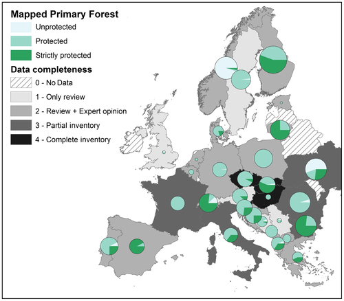
Conducted by Francesco Sabatini and his team from Humboldt University in Berlin, with input from 56 new experts, this update includes a further 700,000 hectares.
It brings the total so far covered to 2.1 million hectares, or just over 1% of forested area – plus European Russia (up to the Ural Mountains) which holds a gigantic 35.5 million hectares.
Countries added include Albania, Belarus, Bosnia, Latvia, Moldova, Russia, Serbia, Sweden and the United Kingdom.
Yet to be published, this update was funded by the Griffith programme of Frankfurt Zoological Society in conjunction with Wild Europe.
Next steps to address a growing threat
A further 3% of European forest cover is thought to exist in primary condition (outside Russia) – with more in Turkey and the Caucasus. Adding this would bring the total of primary forest to just 4% of total forest cover.
Even though the majority of primary forest is nominally under some form of protection, only half is strictly protected. The remainder is under threat, particularly from illegal logging and the rapidly growing use of wood for bioenergy.
With only around a quarter of primary forest so far mapped in Europe (outside Russia), further mapping and recording of status is a vital first step in establishing full protection.
Funding for this third stage is now being sought.
Definitions
Primary forests have no clearly visible indications of human activity, should have no current intervention and are subject to natural ecological processes. They represent an overall category encompassing old growth forest – a late successional stage – and, where applicable, virgin forest. Generally small and fragmented, they tend to occur in remoter areas and on steep slopes where logging is difficult.
The definition used in the mapping exercise is from FAO (FRA 2015 Forest Resources Assessment Working Paper 180).
The original mapping exercise
The original mapping exercise for primary forest was unveiled at Wild Europe’s Brussels conference in 2017, and published in 2018 by Francesco Sabatini and his Humboldt University team.

The mapping covered 1.4 million hectares in 32 countries (0.7% of Europe’s forest area).
The mapping exercise determined that, even though 90% of primary forests are nominally under some form of protection, over half (54%) do not have strict protection.